
My Sandcrawl Method is a guest post by Paul Quarles/Brooding Paladin.
For my The Refining Forge campaign, a Castles & Crusades campaign, I decided to run a sandbox, hexcrawl campaign, or a Sandcrawl campaign as dubbed by Johnn Four.
My last campaign struggled as a pure hexcrawl campaign with two key problems:
-
-
- The players felt it was too wide open and got paralyzed in their decision making
- The GM (me) spent all his time trying to determine the contents of all the subhexes and struggled with motivation (very nearly burnout)
-
This newer approach has been a lot more organic and has even proven to be so fun for me as the GM that prep is now something I look forward to.
Part of the fun is in the initial randomization and then applying GM creativity that makes the random relevant to the campaign.
My Technique
First, I found a real life location that was to serve as my campaign map.
What is great about this is that I don’t have to worry too much about getting biome structure and topography to be realistic or consistent in nature because it already exists that way.
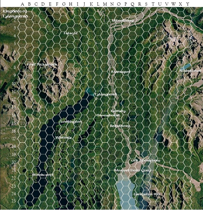
I was going for a colder region that would be set on the northern shores of a continent in Aihrde (the setting for Castles & Crusades). I settled on this beautiful satellite map of Katmai National Park in Alaska.
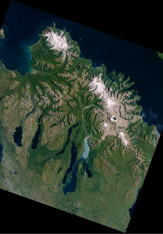
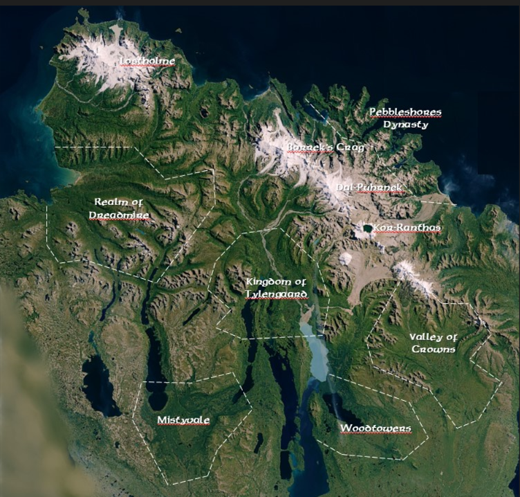
To make it even more difficult to recognize, and to fit my location, I rotated the map 180 degrees to form a northern shoreline. The next step was to break the region down into various political lines.
With that done, I was ready to get started in earnest.
I tend to consider my campaign in Beginner-Intermediate-Advanced levels so I want my players to start off in a small town in the Kingdom of Tylengaard, eventually grow beyond that, and then get to the real heavy stuff in the Dwarven Kingdoms to the north.
So I decided to zero in on Tylengaard first. Again, the natural map is a huge help for this. Here is what the Kingdom looks like:
So far, so good.
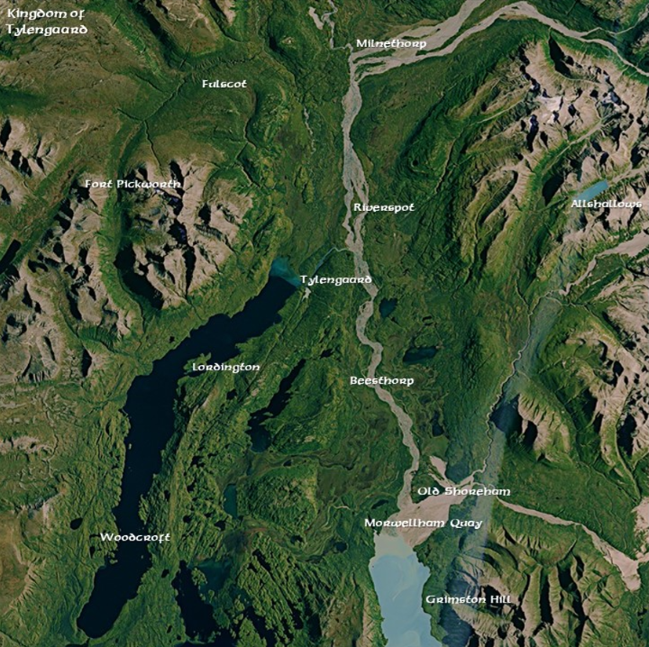
Now I have a great place to start and some good variety in the topography to exploit for overland adventuring, etc.
The next step is really the first stage in getting the Sandcrawl going.
After a few light adventures of the party getting to know itself, they landed in the small village of Lordington and started connecting with some NPCs and completed their first real adventure.
Now the Sandcrawl can begin!
So the next step was to overlay hexes over the entire region just so I could identify where I was at any given time. It’s a little busy but here’s what that looks like:
Now I can zoom in on the Lordington hex and use that as my starting point.
This was really the most involved part so far.
I needed locations, NPCs, adventures, treasure, rumours, all the usual stuff.
Once that was done, the adventuring party felt established and connected and I could introduce them to an NPC that is a locally famous ranger who would certainly know the surrounding area and could drop rumours and leads to adventures around the area and beyond.
That’s when I really needed to get my hexes rolling.
Another motivator was the great idea shared in Johnn Four’s Roleplaying Tips where the suggestion was to pin treasure to the map to seed rumours and inspire your adventurers.
But for me, I found it a little challenging to just place treasure and then build around that.
My brain wanted something there first so I could then place the treasure, but I definitely knew I wanted to use the technique.
This issue gets resolved by this method.
There are several mapping tools out there but I am using Inkarnate.
I am very much a newb at using it so I’m sure my mapping method can be improved, but for now this works.
The first thing I did was draw a map of Lordington in its hex. Here is what that looks like:
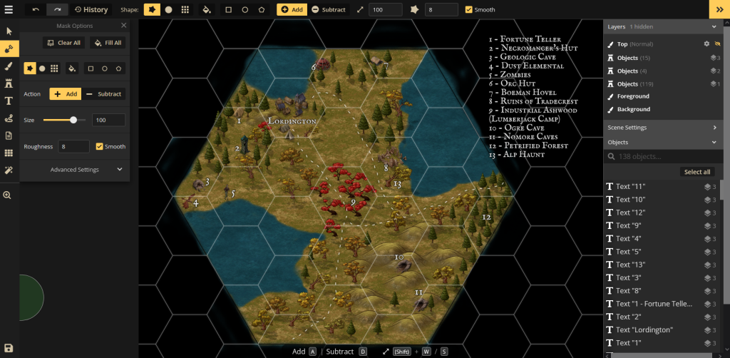
Here’s a slightly closer view to see the detail.
Within the main hex are subhexes.
Each “main” hex will be 6 miles total (7 miles vertex to vertex) and the subhexes are 1.2 miles from face to face.
This helps in determining overland travel rates, etc.
Now that the party is ready to set out and travel a little farther, I needed to start thinking about the hexes around them.
After all, how good would that ranger I just introduced them to be if she had no clue about what was just to the south of the village? Here are the specifics of my Sandcrawl method.
Sandcrawl Method
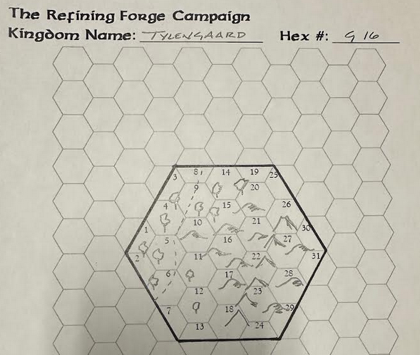
First, I made my own blank hex page for first drawing the details of the hex. It looks like this (apologies for the photography skill, I’m really bad at it):
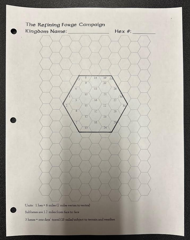
You can print out your own free hex paper at Mathpolate.
Now I’ve got a blank sheet of paper, a pencil, and my original hex-overlaid-topography map to get started.
With a look at that, I note that Lordington is located in Hex G-15 and I want to know what is just south of the Lordington map.
So I check my hex map again and label that one G-16 adding Tylengaard to the Kingdom Name so I can keep them straight going forward. I then enlarge and zero in on the hex so I can see the topographical details and start drawing.
Here’s that closeup:

It’s pretty fuzzy but that’s a limitation of the JPG I’m using for my map. But it’s enough to get my pencil going.
I see a low mountain range cutting through it, plenty of green, and some lower hills. I know I have a road cutting through the hex as well. Awesome. I’m no great artist but at least I know what I’m looking at when I’ve drawn it.
Here is that drawing:
Next, I need some fun/interesting locations.
For that I use a great resource called “Filling in the Blanks – A Guide to Populating Hexcrawls” by Todd Leback. This has become indispensable to my Sandcrawl crafting for the great ideas, random generation, and occasionally forcing me to add something in that I would not have otherwise considered.
That last part has made me a more creative gamemaster for sure.
The author suggests the GM add two kinds of locations sprinkled throughout the hex: Features and Lairs.
I won’t give away all their secret sauce so I’ll reference that you can buy your own copy.
After making the appropriate random rolls and making a few notes, I capture the notes just below my drawing and place the locations into the subhexes.
Here is what that looks like:
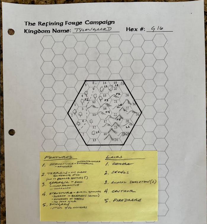
For the Lairs part, I have another resource I can use from Castles & Crusades.
It is the C&C Encounter Tables and Monster Index to help me randomize what might be out there. I have my own methods for randomizing what level of monster I should be considering, and then I check the appropriate “Overland” table, roll, and make a note.
So with my sticky note serving as my legend I locate each feature and lair on a subhex in the main hex above.
I could stop there and rinse and repeat.
I also have locations where I can place treasure and the like and now I’m really off and running with rumours, reasons for them being there, lore, and the like.
While you could stop there, I don’t.
Back to Inkarate for me.
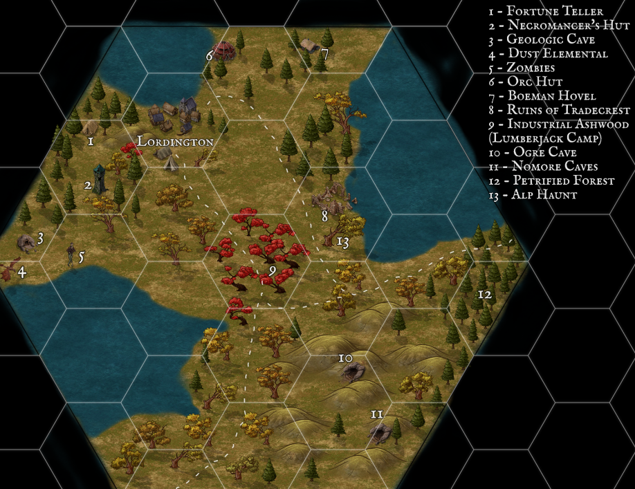
With my hand drawn map as my reference, I now recreate that map in Inkarnate and label it. The above example is rendered thus:
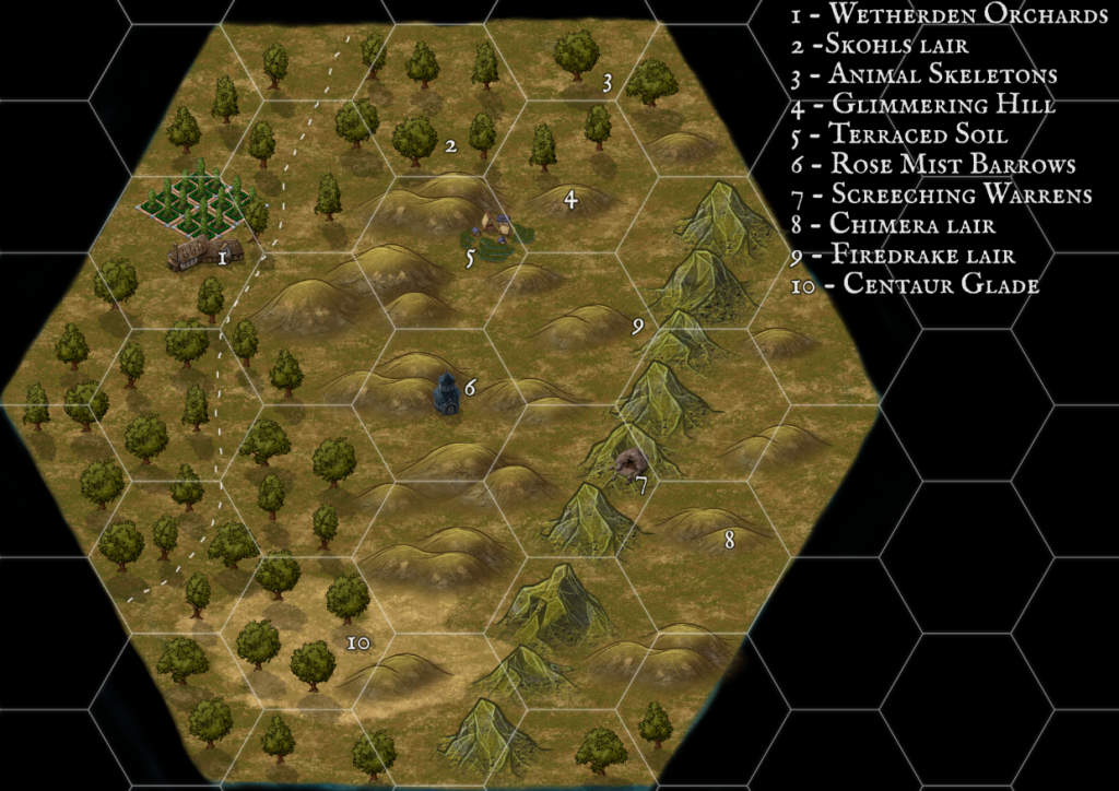
Note, this is the GM’s map.
I also make an unlabelled copy that I can share with my players (we have an online only game) to help them see the area.
When they stumble onto a labelled area is when the real fun begins.
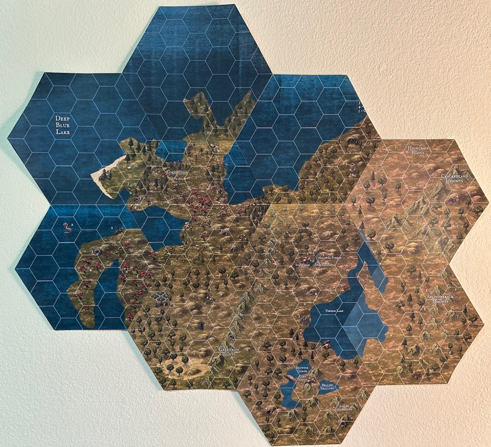
I could also stop there but since I’m a little bit “extra” I actually print the above hex out, get out my Exacto knife, perform surgery (mostly on the hex, sometimes on me by accident) and trim off the GM’s copy (the labeled copy) of the hex.
Then I’m ready to attach it to my starting hex of Lordington. So far, this is what that looks like:
And honestly, I’ve already prepped way more than I might ever need to depending on the players’ choices, but the truth of the matter is it’s so fun I do it if I have a little downtime for my own entertainment.
And it is certainly no waste of time as I’m developing local lore, rumours, etc. almost effortlessly. While I’m drawing the map my mind is already creating backstory for each location.
In all, with the early prep work done, I’ve created a repeatable process that takes me less than an hour and a half to complete all the steps (for a single hex) starting with an empty hex.
And most of that time is spent in the Inkarnate mapping tool since I am still so new to it.
At any rate, that’s my method.
I’m not sure how well I described everything and the pictures were definitely a little sketchy so if you have any questions please feel free to put them in the comments.
While You’re Here…
Since 2021 I have been publishing d12 Monthly, a monthly zine, which has a ton of articles for any edition of Dungeons and Dragons.
Printed copies are available in my store. The PDF is available on DriveThruRPG and you can get both, plus support my work, via my Patreon.
I will also be releasing some more products in the near future.
Feel free to reach out to me on Twitter or my contact page any time.
Yea, that map on the wall is great! I miss having a dedicated play space. I like FitB a lot and use it myself. Seems like a lot of action for a 6 mile hex, but my whole town fits in one!
Thanks heaps, Richard.
This was very interesting, thanks for posting. I especially liked the pieced-together map.
Cheers, Christer! It was very well point together.